Orange rain warning continues as rain spreads north
A wet and windy Sunday is the main story, with an Orange Heavy Rain Warning for Grey, Buller and Nelson Lakes, Heavy Rain Watches spreading into Taranaki and southern Wairarapa, and snow possible on several high road passes.
A complex low and its fronts are spreading rain across the South Island today, with the heaviest falls focused on the west and ranges. The Orange Heavy Rain Warning remains in force for Grey, Buller and Nelson Lakes, while Heavy Rain Watches now cover Taranaki north of Taranaki Maunga and the south and east of Wellington and Wairarapa away from the Tararua Range. Road Snowfall Warnings are also in force for Crown Range Road, Lindis Pass and Lewis Pass. Rain spreads into the central and lower North Island later today and tonight, followed by a cooler, showery southwest flow.
Official severe-weather status
MetService is the official source for New Zealand severe-weather warnings. These are the live products returned by the current warning-feed check late Sunday morning; a Watch or Outlook is not the same as a current Warning.
Heavy Rain Warning - Orange
Grey and Buller Districts and Nelson Lakes
Period: 16 hours from 9am Sunday 6 September to 1am Monday 7 September. Expect a further 100–140mm about the ranges on top of what has already fallen, and 50–70mm elsewhere. Peak intensities of 15–25mm/h are expected this afternoon and early evening. There is minimal chance of upgrading to Red. Streams and rivers may rise rapidly, with surface flooding, slips and difficult driving possible.
Period: 16 hours from 6pm Sunday 6 September to 10am Monday 7 September. Periods of heavy rain may approach warning criteria, with a moderate chance of upgrading to a Warning.
Period: 15 hours from 11pm Sunday 6 September to 2pm Monday 7 September, for the south and east of Wellington and Wairarapa away from the Tararua Range. Heavy rain spreads north overnight, with amounts possibly approaching warning criteria and a moderate chance of upgrading.
Period: 5 hours from 11am–4pm Sunday 6 September. Rain may fall as snow late this morning and afternoon, with 1cm or less accumulating near the summit.
Period: 7 hours from 2am–9am Monday 7 September. Rain is expected to turn to snow about the summit for a time early Monday, with 2–3cm possibly accumulating.
No Severe Thunderstorm Warning returned in the live feed
The current warning-feed check returned no Severe Thunderstorm Warning. Thunderstorm risk and any later product changes must be checked on the live MetService Thunderstorm Outlook; this page does not infer an official warning from model guidance.
The active products above are the exact warnings and watches returned by the current feed check. The Severe Weather Outlook is the authoritative place to check for broader potential impacts beyond those products and for any later change to Monday’s risk.
Rain is now spreading across the South Island, with the heaviest falls focused on Buller, Grey and the ranges. Rain reaches Taranaki and the lower North Island later today and tonight, with the current Watches covering Taranaki and the south and east of Wellington and Wairarapa. Snow is possible on several high passes, including Crown Range Road and Lindis Pass this afternoon and Lewis Pass early Monday. The upper North Island and Chatham Islands begin quieter, but conditions turn more unsettled as fronts move through.
Northland to Waikato, Coromandel and Bay of Plenty
Cloudy periods and isolated showers increase later today, with a more unsettled southwest flow developing Monday and Tuesday.
Gisborne and Hawke’s Bay
These areas start relatively sheltered, with cloud and occasional rain developing as the system moves north. Conditions become cooler and showery behind it.
Taranaki to Wellington and the central high country
Rain spreads in this evening and overnight. Taranaki north of Taranaki Maunga and the south and east of Wellington have Heavy Rain Watches, with Wellington and Wairarapa watched from late Sunday night.
Nelson, Marlborough and Canterbury
Rain is spreading in, with heavier falls possible near the ranges. Check the live MetService page for any later change to the current warning and watch inventory.
Buller, Grey, Westland and Fiordland
Periods of heavy rain continue, especially in the ranges. The Orange Warning covers Grey, Buller and Nelson Lakes through early Monday, with runoff, slips and difficult driving possible.
Southland and Otago
Rain and showers spread through, with snow possible on high roads. Crown Range Road and Lindis Pass are warned this afternoon; Lewis Pass is warned early Monday.
Chatham Islands
More sheltered at first, with cloud and rain developing as the broader system and stronger winds reach the islands later.
Reported transport context
No materially newer weather-impact report was found in the last 24 hours. The following continuing authority update is still relevant to travel planning and is separate from the official warning inventory above.
SH6 Makarora–Hāwea remains weather-dependent
NZ Transport Agency Waka Kotahi says the route is scheduled to reopen to all traffic during daylight hours this weekend, 8am–5:30pm, with temporary limits and a single-lane section. Rain or fresh slips could cut the reopening short; check the live journey planner immediately before departure.
The next five days
Day 1 · Sunday 6 September
Widespread rain, heaviest in the west. Rain continues across the South Island and spreads into Taranaki and the lower North Island later. The Orange Warning remains the main concern around Grey, Buller and Nelson Lakes, while rain may approach warning criteria in the watched North Island areas. Snow is possible on Crown Range Road and Lindis Pass this afternoon.
Day 2 · Monday 7 September
Rain eases, but the morning stays active. Heavy rain may linger early in watched parts of the North Island and the Orange Warning area. Rain turns to snow around Lewis Pass for a time, then the system gradually breaks into showers as a cool southwest flow spreads across the country.
Day 3 · Tuesday 8 September
Showers become more scattered as the southwest flow eases, with brighter periods developing in many districts. Western and southern areas retain the greater shower risk, while Chatham Islands conditions remain changeable.
Day 4 · Wednesday 9 September
A further front begins to bring rain to western and southern districts, with showers spreading north of the Central Plateau. The northeast of the South Island is more sheltered, but timing and placement of the next change remain uncertain.
Day 5 · Thursday 10 September
Another windy change moves across the country, with periods of rain most likely in western and southern districts and more sheltered eastern areas often partly cloudy or fine. Check the live MetService outlook as the timing and strength become clearer.
Regional detail
Northland, Auckland and Coromandel
Cloud and showers become more frequent today and Monday, with some brighter periods between. Further changes are possible Wednesday and Thursday.
Waikato, Bay of Plenty and central plateau
Showers and rain spread through later today, easing to showers Monday. Conditions remain changeable as the next fronts approach midweek.
Gisborne, Hawke’s Bay and Wairarapa
High cloud and occasional rain develop today, with rain or showers Monday. Wairarapa’s current Heavy Rain Watch applies south and east of the region away from the Tararua Range.
Taranaki, Manawatū, Whanganui and Wellington
Rain arrives this evening and overnight, with current Heavy Rain Watches for Taranaki north of Taranaki Maunga and the south and east of Wellington and Wairarapa. Rain eases to showers Monday.
Nelson, Marlborough and Canterbury
Rain spreads in today, with heavier falls possible near the ranges. Conditions ease Monday before another change later in the outlook; check the live warnings page for updates.
West Coast and Fiordland
Periods of heavy rain continue today, especially in the ranges, then ease to showers Monday and Tuesday. Grey, Buller and Nelson Lakes remain under the Orange Warning through early Monday.
Otago, Southland and Stewart Island
Rain and showers spread through today and ease Monday. Snow is possible on high roads, with current Road Snowfall Warnings for Crown Range Road, Lindis Pass and Lewis Pass.
Chatham Islands
Cloud and rain develop as the wider system reaches the islands, with stronger winds and changeable conditions continuing into Monday and Tuesday.
Travel and outdoor impacts
The immediate concerns are heavy rain and runoff from Sunday into early Monday, snow on high passes, and difficult driving in the western South Island. Rain can trigger slips on already vulnerable routes even where there is no MetService warning.
For Grey, Buller and Nelson Lakes, the Orange Heavy Rain Warning runs 9am Sunday–1am Monday. Clear drains and gutters, avoid low-lying areas, and drive cautiously as streams and rivers may rise rapidly.
Heavy Rain Watches cover Taranaki north of Taranaki Maunga and the south and east of Wellington and Wairarapa away from the Tararua Range. Each has a moderate chance of upgrading.
Crown Range Road and Lindis Pass (SH8) have Road Snowfall Warnings from 11am–4pm Sunday, with 1cm or less possible near the summits. Lewis Pass (SH7) is warned from 2am–9am Monday, with 2–3cm possible near the summit.
SH6 between Makarora and Hāwea is scheduled for limited daytime reopening but remains subject to rain and fresh slips. Check NZTA immediately before departure and do not rely on this briefing for road access.
Forecast evidence and uncertainty
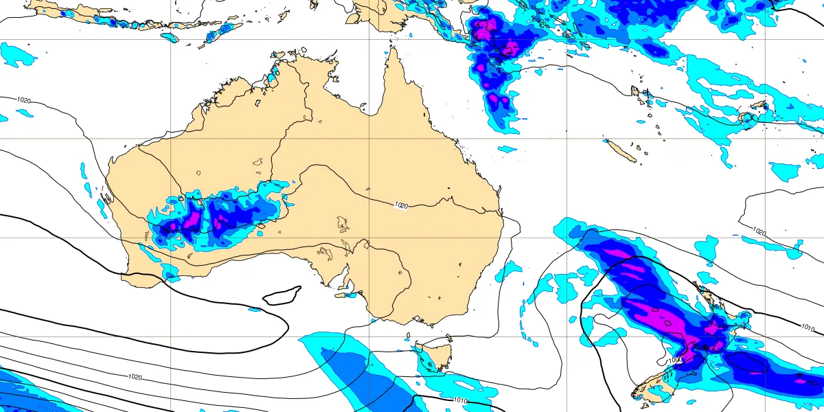
The latest available public ECMWF control chart shows the Sunday rain-bearing low and a broad band of precipitation crossing the South Island, consistent with the MetService warning pattern. The ensemble mean and spread chart for Monday keeps the low-pressure signal near central New Zealand, but the spread around the pressure field highlights uncertainty in the exact track, timing and placement of the heaviest rain. The model evidence supports the trend; it does not create or change a New Zealand warning, and MetService remains authoritative.
Sunday’s rain-bearing system: ECMWF control forecast rain and mean sea-level pressure, base time 18 UTC Saturday 5 September, valid 12 UTC Sunday 6 September (T+18), Australasia. View sourceMonday’s uncertainty: ECMWF ensemble mean and spread for mean sea-level pressure, base time 12 UTC Saturday 5 September, valid 12 UTC Monday 7 September (T+48), Australasia. Wider spread indicates more disagreement in pressure detail and timing. View source
MetService Watches and Warnings — live warning-feed check about 11:47–11:59am Sunday; one Orange Heavy Rain Warning, two Heavy Rain Watches and three Road Snowfall Warnings shown above
ECMWF Open Charts — control forecast valid 12 UTC Sunday from the 18 UTC Saturday run and ENS mean/spread valid 12 UTC Monday from the 12 UTC Saturday run; images retrieved late Sunday morning NZST